
Super Typhoon Sinlaku Barrels Toward US Territory as 2026’s Strongest Storm
Somewhere over the Western Pacific, a cluster of small, scattered disturbances began feeding off warm ocean water. Nobody raised alarms at first. Storms like these form and fizzle every season, dissolving before they earn a name. But Sinlaku refused to fizzle. By April 9, it had consolidated into a typhoon, and by April 13, it had become something far more menacing. With violent wind gusts clocking 190 miles per hour according to Japan Meteorological Authority data, Sinlaku earned a grim title. It became the most powerful storm on the planet so far in 2026. And it was heading straight for US territory.
Why “Typhoon Alley” Breeds Beasts Like Sinlaku
Understanding Sinlaku means understanding where it was born. A stretch of the Western Pacific Basin known informally as Typhoon Alley produces some of the most ferocious storms on Earth, and for good reason. Ocean temperatures here run hotter than anywhere else on the open sea, feeding cyclones a steady diet of heat and moisture. An enormous basin width gives storms thousands of miles of uninterrupted water to gather size and power before reaching land.
Most hurricanes in the Atlantic never get the runway Sinlaku did. Pacific typhoons can churn for days across open water, building into monsters that dwarf their Atlantic cousins. Sinlaku took full advantage. Rolling northwest from its birthplace, the storm intensified at a pace that caught forecasters’ attention and prompted urgent warnings across the Mariana Islands.
Sinlaku Sets Its Sights on the Marianas

By April 13, forecasters at the US National Weather Service had seen enough. Sinlaku’s path pointed directly at the Northern Mariana Islands, a chain of US territories scattered across the Pacific like stepping stones. Even as models predicted gradual weakening, the NWS made clear that gradual would not mean safe.
“Sinlaku is expected to gradually weaken the next few days, but is still expected to cross the Marianas as a category 4 or 5 typhoon,” the NWS said in a statement on Monday, April 13.
A Category 4 or 5 typhoon can shred buildings, uproot forests, and reshape coastlines. For the roughly 50,000 people living across these islands, that statement carried a simple message. Prepare now or face lethal consequences.
Guam, the largest and most populated island in the chain, appeared to sit outside Sinlaku’s direct path. But proximity to a storm of this magnitude still meant heavy rainfall, flooding, and dangerous ocean swells. No one in the Marianas could afford to look away.
Wednesday Night, April 15 — Where Sinlaku Sits Right Now
By Wednesday evening local time, Sinlaku’s eye had crawled northwest of Tinian and Saipan. At 7 PM ChST on April 15, the NWS placed the storm’s center near 16.2°N latitude and 144.8°E longitude, roughly 190 miles north of Guam. It was moving northwest at just 6 miles per hour with sustained winds of 125 mph.
Typhoon warnings remained active for Rota, Tinian, Saipan, Alamagan, Pagan, and Agrihan. Guam sat under both a tropical storm warning and a typhoon watch. A flood watch covered every island in the chain.
Sinlaku’s sluggish pace made matters worse. A fast-moving storm blows through and moves on. A slow one lingers, dumping rain hour after hour, pushing wave after wave against the shore. Sinlaku chose to linger.
Tinian and Saipan Take the Hardest Hit
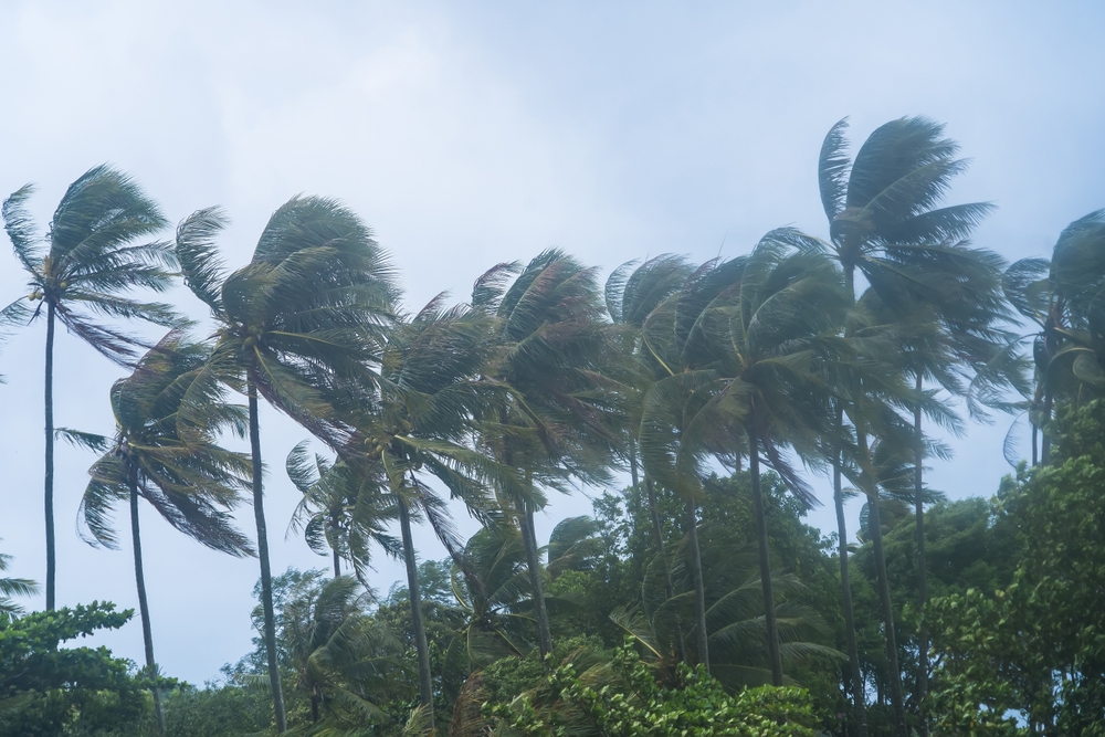
Of all the islands in Sinlaku’s crosshairs, Tinian and Saipan absorbed the worst punishment. South to southwest winds screamed at 60 to 70 mph, with gusts reaching 100 mph as the eye drifted slowly northwest. NWS forecasters warned that destructive winds would continue through late Wednesday night.
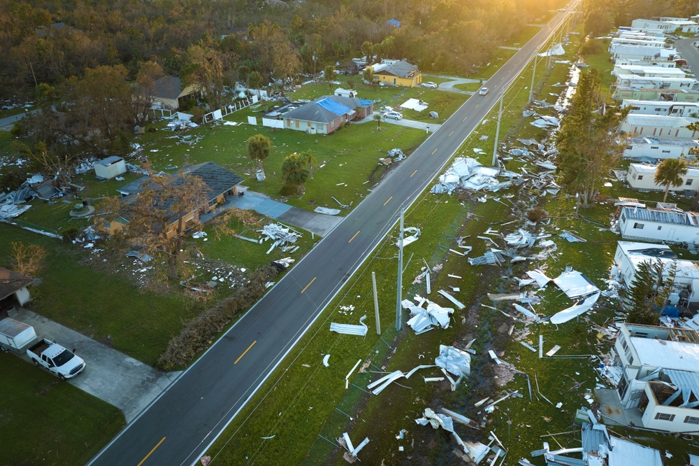
Destruction extended well beyond wind damage. Most trees on both islands faced snapping or uprooting, and forecasters expected fallen timber to cut off residential neighborhoods for days, possibly weeks. Metal-roof homes that survived earlier storms faced near-certain destruction. Electricity and water service would likely remain unavailable for an extended period after the storm’s passage.
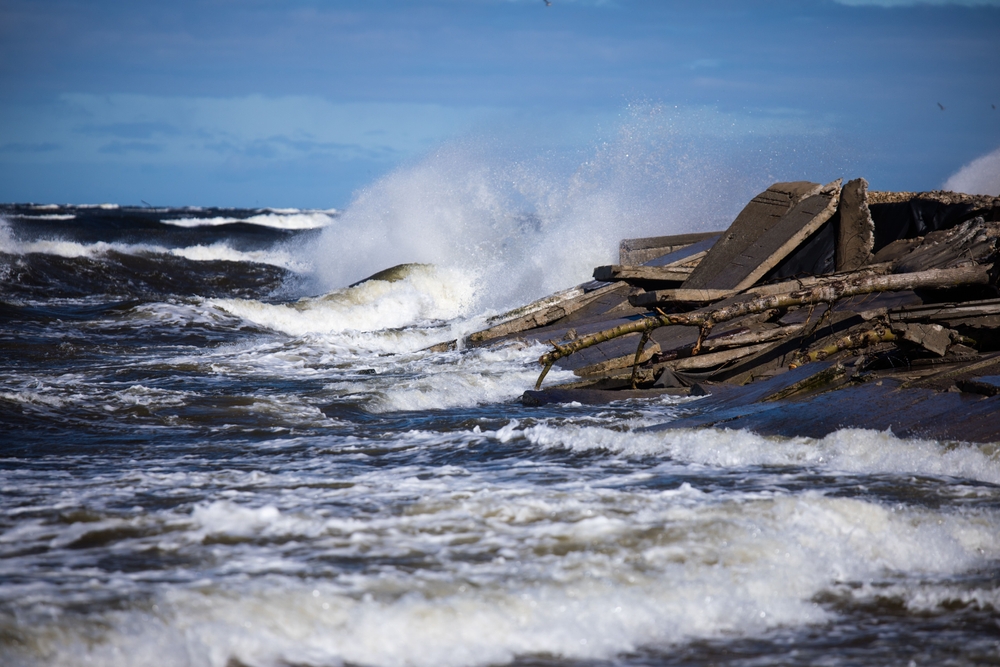
Along the coast, conditions turned nightmarish. Surf of 20 to 25 feet hammered north, south, and west-facing reefs. Winds had shifted south to southwest, briefly easing conditions on east-facing shores but amplifying the assault everywhere else. Storm surge threatened to push water 10 to 15 feet above the mean water level along windward beaches, flooding coastal roads and low-lying structures. Inland flooding worsened as rain, runoff, and storm surge collided, creating a compounding effect that multiplied damage.
An additional 4 to 8 inches of rainfall remained possible for both islands through Wednesday night, stacking on top of what had already fallen.
Guam Braces for the Outer Bands
Guam dodged the eye, but nobody on the island felt lucky. West-southwest tropical storm winds of 40 to 50 mph, with gusts reaching 70 mph, continued hammering the island through Wednesday afternoon. Dangerous surf between 13 and 18 feet battered south, west, and north-facing reefs, while east-facing reefs still faced hazardous conditions at 10 to 13 feet.
Rain had already saturated the ground. Between 8 and 12 inches had fallen before Wednesday, and even a quick 1 to 2 inches from stray rain bands could trigger flash flooding on waterlogged soil. A flood watch remained in effect.
Winds were expected to finally drop below tropical storm force late Wednesday night or early Thursday morning. But even after the wind died down, residents were told to stay indoors until the government of Guam issued an official all clear. Flying debris remained a threat even as conditions slowly improved.
Rota Rides Out the Storm’s Edge
Rota, positioned between Guam and Saipan, caught a lighter blow but still faced serious conditions. Southwesterly winds of 40 to 50 mph with gusts to 65 mph raked the island, especially when heavy rain bands swept overhead. Forecasters considered the chance of full typhoon-force winds of 75 mph to be remote for Rota.
Surf of 13 to 18 feet pounded west-facing reefs, wrapping around to north and south shores. An additional 3 to 6 inches of rain remained possible, and winds were expected to drop below tropical storm force by Thursday morning.
Northern Islands Brace for a Direct Brush
Alamagan, Pagan, and Agrihan, the remote northern islands of the CNMI chain, faced a different kind of danger. Sinlaku’s track would carry it just west of all three islands from Wednesday night through Thursday night before curving northeast and passing north of Agrihan by Friday.
Typhoon-force winds of 75 mph could begin reaching Alamagan late Wednesday night, Pagan by Thursday morning, and Agrihan by Thursday afternoon. Rainfall totals of 10 to 15 inches were expected by Friday, with amounts near the storm’s center reaching 15 to 25 inches. Seas of 20 to 30 feet remained possible, bringing severe coastal flooding and beach erosion.
“Stay indoors during heavy rain and windy conditions associated with Super Typhoon Sinlaku. The onset of damaging, and potentially destructive winds, will pose a deadly threat to those venturing outside,” the NWS warned.
With tiny populations and minimal infrastructure, these northern islands had few resources to draw on. Preparation windows had closed. Survival now depended on sturdy shelter and patience.
A Slow Exit and a Long Recovery Ahead
Sinlaku would not leave quickly. Its massive size and crawling speed meant tropical storm winds would take days to fully subside across the island chain. Guam’s winds would drop below damaging levels late Wednesday night. Rota will be clear on Thursday morning. Tinian and Saipan would not see relief until Thursday evening or night. And heavy swells would continue battering western Mariana shores through the rest of the week, long after Sinlaku accelerated northward and left the region.
Recovery timelines remained uncertain. With power and water infrastructure likely damaged on Tinian and Saipan, communities could face weeks without basic services. Fallen trees blocking roads would slow rescue and supply operations. Coastal flooding would leave salt-soaked soil and debris across shoreline communities.
South of the Equator, Another Deadly Storm Already Left Its Mark

While all eyes tracked Sinlaku in the northern Pacific, another major cyclone had already finished its destructive work to the south. Tropical Cyclone Maila gathered strength over the Solomon Sea, the body of water between Papua New Guinea and the Solomon Islands, at a latitude unusually close to the equator for a storm of its power. Over the previous weekend, Maila made landfall in Papua New Guinea and killed at least 11 people, including eight in a landslide and two struck by falling trees.
Two major cyclones churning simultaneously across the Pacific served as a reminder. Storm season spares no one, and geography offers no guarantees.
What Residents Should Do Right Now
For anyone still riding out Sinlaku across the Marianas, the NWS guidance was clear and urgent. Stay indoors and away from windows. Remain in designated shelters or reinforced concrete buildings until officials issue the all clear. Monitor NOAA Weather Radio and local news for forecast updates, flash flood warnings, and any changes to evacuation orders.
“For those under a Warning in the Marianas, the window of time to complete preparations for the protection of life and property is very soon to close. Evacuate if directed to do so by local officials, or if your home is vulnerable to high winds or flooding,” the NWS stated.
Sinlaku would eventually pass. But for the people of the Mariana Islands, the hours ahead would test everything they had prepared for.